

A devastating 7.1 magnitude earthquake rocked the Shigatse region of Tibet, China, on January 7, causing significant geological disturbances and raising alarms over potential Glacial Lake Outburst Floods (GLOFs).
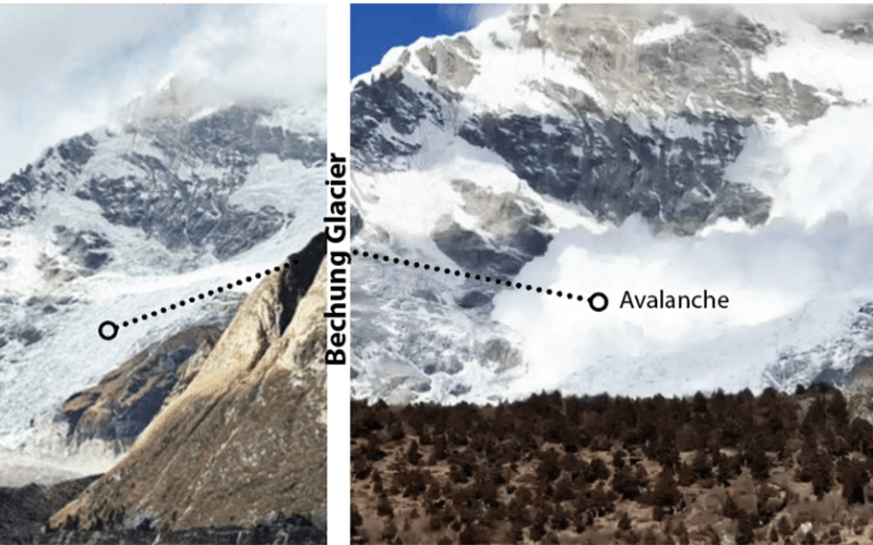
The seismic event triggered two avalanches from the Table Mountain massif above the Bechung Glacier in Lunana. Fortunately, the glacier’s gentle slope absorbed the avalanches, preventing them from reaching the nearby Bechung Glacial Lake. However, experts warn that such incidents could act as catalysts for dangerous GLOFs, which pose severe risks to downstream communities.
The earthquake’s tremors were widely felt across neighboring countries, including Bhutan. Gasa, the closest dzongkhag to the epicenter, experienced the highest intensity of shaking, registering four on the Modified Mercalli Intensity (MMI) scale. This scale measures the perceived strength of seismic activity, with the MMI IV indicating noticeable shaking by residents.
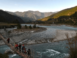
Lunana, an area home to numerous glaciers like the perilous Thorthomi Lake, remains particularly vulnerable to seismic activity due to its glacial landscape. Key glacial lakes situated below Table Mountain—Bechung, Rapstreng, Thorthomi, and Lugye Tsho—are under close scrutiny following the earthquake.
Phuntsho Tshering, executive glaciologist at the National Centre for Hydrology and Meteorology (NCHM), explained, “The vibrations destabilize glaciers, triggering avalanches. Fortunately, this recent avalanche occurred on the Bechung Glacier side, which has a slope capable of absorbing the impact. However, Bechung Glacier Lake is rapidly expanding, raising concerns about its structural integrity.”
Immediate response measures were swiftly implemented as communities in Lunana were alerted to the potential dangers. NCHM personnel from Lunana, alongside a team from headquarters, were dispatched to evaluate the status of the glacial lakes. While no major disturbances were detected at Thorthomi, Rapstreng, and Bechung glacial lakes, minor moraine slides were observed on the inner moraine walls of the Thorthomi-Rapstreng barrier. Access to Luggye Glacial Lake remained restricted due to winter conditions.
The Thorthomi-Rapstreng moraine dam, crucial in preventing a GLOF, has been deteriorating over the years. A collapse could result in the combined outflow of Thorthomi and Rapstreng lakes, potentially unleashing up to 53 million cubic meters of water in a worst-case scenario, according to NCHM studies. This makes Thorthomi Lake the most hazardous among the glacial lakes in the region.
In response to these threats, efforts to permanently relocate residents from the vulnerable villages of Thangza and Tenchoe in Lunana to safer, higher elevations in Damthangkha, Bayza-Gangjuk, and Dungbiteng have been ongoing since last year. These relocations aim to minimize the risk to lives and properties in the event of a GLOF.
NCHM officials have assured that monitoring of the glacial lakes will continue, with downstream communities advised to remain vigilant. While the earthquake’s tremors were mild in other parts of the country, with intensities ranging between zero and three on the MMI scale, western Bhutan felt a noticeable intensity of two.
In terms of ground shaking, an intensity of four on the MMI scale equates to a ground movement of approximately 15 centimeters per second squared, or 0.0153 times the force of gravity (0.0153g). Current building codes in the region are designed to withstand significantly stronger ground movements, up to 0.36g, ensuring the structural safety of most constructions.
Looking ahead, the Department of Geology and Mines, in collaboration with the GovTech Agency, is upgrading Bhutan’s earthquake monitoring systems, a project slated for completion by the end of March. The enhancement includes a web-based platform that will provide real-time earthquake intensity information and enable public reporting of perceived shaking. Presently, Bhutan operates 13 seismic monitoring stations and 223 intensity meters nationwide to measure and track earthquake activity.
As the region braces for future seismic events, the collaborative efforts of scientists, government agencies, and local communities remain crucial in mitigating the risks posed by earthquakes and their potential to trigger catastrophic glacial lake outbursts.