

In a development raising alarms in Washington, AI-enhanced satellite imagery from a Chinese geospatial firm is reportedly aiding Iranian forces in targeting US and allied military assets in the Middle East with unprecedented accuracy.
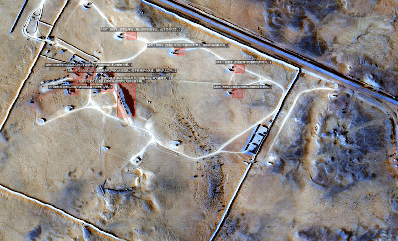
According to an exclusive ABC News report citing a source within the US Defense Intelligence Agency (DIA), the Iranian Revolutionary Guard Corps (IRGC) has been using detailed, AI-processed satellite images published by Hangzhou-based MizarVision. These images, which incorporate automated object recognition and tagging, allow identification of bases, aircraft, equipment, and infrastructure to within roughly a third of a square metre.
US intelligence believes the material informs Iranian missile and drone targeting protocols, helping prioritize high-value assets. “This is an example of a Chinese company, we believe maliciously, providing intelligence on an open-source platform,” the DIA source told ABC. The Pentagon assesses that the IRGC monitors and applies this data for strikes.
MizarVision, which holds a Chinese National Military Standard certificate and has partial government ties, has publicly released imagery of key US facilities including Al-Udeid Air Base in Qatar, Prince Sultan Air Base in Saudi Arabia, and others. The company leverages commercial satellite data—both Chinese and Western—combined with AI to analyze movements of US carrier groups, strike aircraft, and ground deployments amid the ongoing Iran conflict.
The Washington Post reported that multiple private Chinese firms with links to the People’s Liberation Army are marketing similar AI-driven intelligence derived from open-source data, including flight trackers and satellite feeds. Analysts describe this as a form of “commercialized espionage” that blurs lines between civilian tech and military support, effectively outsourcing targeting intelligence to Tehran while Beijing maintains official distance.
Retired military experts, including Australian analysts, warn the capability puts allied troops at risk and represents one of the most direct forms of Chinese technological assistance to an adversary of the US in recent years. It highlights broader concerns over dual-use AI and satellite technology in modern conflicts, where commercial tools can rapidly enhance precision strikes.
Neither MizarVision nor Chinese officials have publicly commented on the allegations. The revelations come as the US has urged satellite imagery providers to restrict access to conflict-zone data to prevent adversary exploitation.